
UPDATE: March 2024 – Places for Everyone Adoption
The Places for Everyone Plan took effect and became part of the statutory development plan for each of the nine PfE authorities on March 21, 2024.
More information can be found here - Places For Everyone - Greater Manchester Combined Authority (greatermanchester-ca.gov.uk).
If you have an enquiry for the Planning and Housing Team please redirect your email to planningandhousing@greatermanchester-ca.gov.uk.
Places for Everyone
We have ambitious plans to give people, communities and businesses hope and confidence for the future. We are a pioneering city-region that is open for business locally and internationally; a thriving, prosperous place that supports everyone to reach their full potential and ensures no-one is left behind.
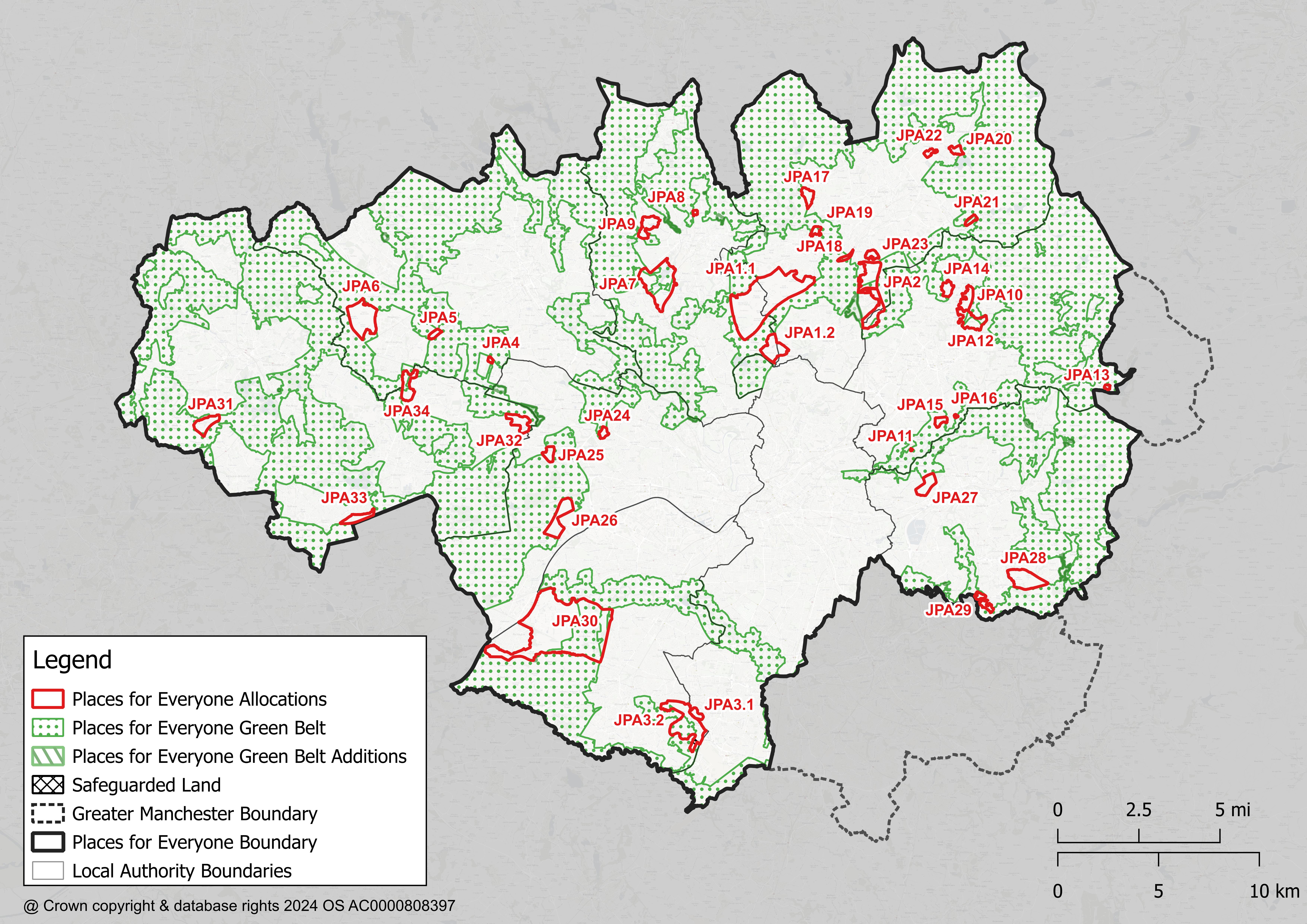
The maps on this site show the evolution of the proposals contained within the new joint plan, ‘Places for Everyone’, which is a joint plan between nine Local Authorities – Bolton, Bury, Manchester, Oldham, Rochdale, Salford, Tameside, Trafford and Wigan – which aims to bring these ambitions to life.
The maps allow you to understand the proposed boundaries of sites, as well as view important contextual information.
For historical purposes, you may also wish to view information about the GMSF and the maps created for it here on MappingGM.
You can view the adopted policies map on the GMCA Website
What is this plan and why do we need it?
Our joint plan has been born from a collective ambition to build better, affordable, more sustainable homes so we can all enjoy happier, healthier lives with more opportunities for everyone who lives and works here.
We want to work together to make sure that our areas are dynamic, and attractive places to invest and do business.
To enable us to do this we need to build the right homes, in the right places so we can all live in well-connected and environmentally sustainable villages, towns and cities.
What has happened so far?
- In 2016, working with our leaders and a range of planning specialists, we developed an ambitious, progressive plan that saw us pool the collective resources we have across the city region. We put this plan to the people of Greater Manchester and listened to the feedback of over 27,000 residents and business.
- Based on this feedback we undertook a significant review and rewrote these plans, reducing the impact on our Green Belt and building homes that meet our future needs and enable us to meet our ambitious target of being carbon neutral by 2038.
- We went back to our communities and partners in 2019 to check these plans, with 17,000 responses to our updated proposals.
- We reviewed this feedback and worked with partners across the Districts to refine the plan.
- In December 2020, Stockport Council withdrew from the GMSF. The remaining nine authorities agreed to progress a joint plan – Places for Everyone (PfE). That plan was consulted on between 9 August and 3rd October 2021.
- Following consideration of the responses to that consultation, the PfE Plan was submitted for independent examination on 14 February 2022.
- The hearing sessions took place between November2022 and July 2023.
- We consulted on a number of modifications to the PfE Plan between 11 October and 6 December 2023.
- The responses received were published on the GMCA website and shared with the inspectors.
- More information in relation to the Modifications stage can be found on the GMCA website. The Inspectors considered the representations made and published their report.
- The Places for Everyone Plan took effect and became part of the statutory development plan for each of the nine PfE authorities on March 21, 2024. More information in relation to the adoption of the plan including the adopted Policies Map can be found on the GMCA website.
- An archive of maps which have been created on MappingGM as part of the development of the Greater Manchester Spatial Framework (GMSF), and the Places for Everyone (PFE) plan exists, including:
- A Call for Sites map that asked the public to submit potential areas for development.
- A map supporting the 2016 GMSF Consultation.
- A map supporting the 2019 GMSF Consultation.
- A map supporting the 2021 Places for Everyone Consultation.
- A map supporting the 2023 Modifications Consultation.
Guide to using the maps
This guide will provide you with more information on how to use and navigate the maps.
Queries and comments
If you would like any further information on the joint plan or the maps used within, you can contact the Planning and Housing team by email.
Developed by:
